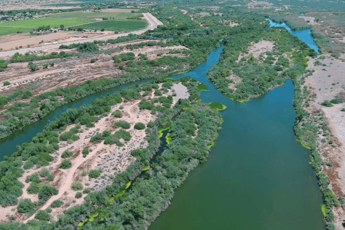
Voices from across Arizona are coalescing into a powerful movement aimed at restoring the ecological health and functional vitality of the Lower Gila River, a critical artery flowing through the heart of the state. This ambitious initiative, spearheaded by the Lower Gila River Collaborative (LGRC), seeks to reverse decades of environmental degradation caused by historical land and water management practices exacerbated by a hotter, drier climate. The collective effort focuses on strategic habitat restoration, mitigating flood and fire risks, enhancing recreational access, and fostering economic opportunities along the vital 36-mile stretch of river from the City of Phoenix’s Tres Rios Wetlands to Gillespie Dam south of Arlington.
Historical Significance and Ecological Imperative
The Salt and Gila Rivers, foundational to Arizona’s development, have long served as a lifeblood for communities, Tribal nations, agriculture, and industry. Their waters have sustained civilizations for millennia, from early Indigenous peoples who engineered sophisticated irrigation systems to modern metropolises. Beyond their utilitarian value, these river corridors represent an irreplaceable natural heritage, connecting people to nature and providing crucial habitat for a diverse array of flora and fauna. So significant is this biodiversity that the Lower Salt and Gila Rivers Ecosystem has been formally recognized as an Important Bird Area (IBA). This designation underscores its paramount importance for avian species, including the federally endangered Yuma Ridgway’s Rail, which relies heavily on the unique marsh habitats the river system provides.
However, the prosperity brought by harnessing these rivers also introduced profound ecological alterations. The construction of major dams upstream, such as Roosevelt Dam on the Salt River and Coolidge Dam on the Gila, along with extensive diversion projects, dramatically altered the natural flow regimes. These infrastructural marvels, while critical for water supply and flood control, disrupted the historical ebb and flow that shaped native riparian ecosystems. These changes, coupled with a warming climate manifesting in persistent drought conditions, have created an environment ripe for ecological imbalance.
The Crisis: Invasive Species, Diminished Water, and Heightened Fire Risk
The confluence of historical management practices and climate change has resulted in significant environmental degradation within the Lower Gila River ecosystem. One of the most pervasive and damaging issues is the proliferation of invasive plant species, primarily salt cedar (also known as tamarisk). This non-native shrub, aggressively introduced in the early 20th century for erosion control, has outcompeted and displaced native vegetation like cottonwoods and willows. The ecological consequences are multifaceted and severe.
Salt cedar forms dense, monocultural thickets, effectively crowding out the diverse native plants that provide essential food and shelter for local wildlife. Its presence also diminishes both the quality and quantity of water in the river system. Salt cedar is highly phreatophytic, meaning it has deep roots that access groundwater, consuming vast amounts of water – an estimated 200 to 300 gallons per mature plant per day – thus exacerbating water scarcity in an already arid region. The altered vegetation also leads to increased soil salinity, further hindering the reestablishment of native species.
Beyond ecological harm, the invasive species pose significant threats to human communities. The dense, overgrown corridors reduce recreational access, making it difficult for residents to enjoy activities such as kayaking, fishing, or hiking along the riverbanks. More critically, these dense thickets create "choke points" in the river channel, impeding natural water flow and significantly increasing the risk of damaging floods during periods of high river flows. When floodwaters encounter these constrictions, they can back up, breach banks, and cause widespread property damage.
The expansion of salt cedar also presents a heightened fire risk, a devastating reality for a desert environment. Unlike native desert plants, salt cedar is highly flammable and burns hotter and quicker, fueling fires that spread more intensely and are more difficult to contain. This characteristic turns the river corridor into a tinderbox, dramatically increasing the frequency and severity of wildfires. The 36-mile stretch of the Lower Gila River has endured numerous such blazes, with the recent Hazen Fire in May 2026 serving as a stark reminder. This particular fire consumed nearly 1,200 acres in the Gila River bottom near Buckeye, demonstrating the destructive potential fueled by invasive species. Fires in dense tamarisk stands have been observed to spread up to three times faster than in areas with native vegetation, posing direct threats to infrastructure, homes, and human lives.
A Coordinated Response: The Lower Gila River Collaborative
Despite these formidable challenges, the Lower Gila River corridor holds immense potential for revitalization. Recognizing this, Audubon Southwest, building upon decades of dedicated work in the area, has joined forces with a diverse array of partners to establish the Lower Gila River Collaborative (LGRC). This voluntary partnership, comprising over 30 state agencies, non-governmental organizations, Tribal entities, and recreation and agricultural water users, is united by a common goal: to restore the river’s health and function. Key members include the Gila River Indian Community; the cities of Avondale, Buckeye, Goodyear, and Phoenix; Maricopa County Parks and Recreation Department; Flood Control District of Maricopa County; Arizona Department of Game and Fish; Arizona Department of Forestry and Fire Management; and U.S. Fish and Wildlife Service.
The LGRC’s strategic action plan is comprehensive, targeting multiple critical areas: advancing strategic habitat restoration by removing invasive species and reestablishing native plants; reducing flood and fire risks through landscape management; improving public recreational access to the river; and boosting economic opportunities within the corridor, such as ecotourism and sustainable land management jobs.
Key Stakeholders and Policy Engagement
To galvanize support and advance the conversation around these critical issues, Audubon Southwest hosted the Lower Gila River Forum at the Nina Mason Pulliam Rio Salado Audubon Center. This pivotal event convened a broad spectrum of stakeholders, including state leaders, city council members, Tribal representatives, water agencies, and congressional staff from the offices of U.S. Reps. Greg Stanton (D-Ariz.) and Yassamin Ansari (D-Ariz.), and U.S. Sens. Mark Kelly (D-Ariz.) and Ruben Gallego (D-Ariz.).
U.S. Rep. Juan Ciscomani (R-Ariz.) provided virtual opening remarks, emphasizing the bipartisan commitment required to address such complex environmental challenges. He likely highlighted the shared responsibility of federal, state, and local entities in securing the long-term health of Arizona’s vital water resources and ecosystems, stressing that the river’s restoration is not merely an environmental issue but an economic and community imperative.
Sine Kerr, Arizona’s Farm Services Agency State Executive Director, offered a crucial historical and legislative perspective. Drawing on her tenure as an Arizona State Senator, she recounted her legislative accomplishments, including the landmark 2022 investments in Arizona’s water future. These included the expansion of the Water Infrastructure Finance Authority of Arizona (WIFA) and, notably, securing $5 million for the Gila River Nonnative Vegetation Species Eradication Fund. This direct investment empowered the Arizona Department of Forestry and Fire Management to undertake critical work: the removal of pervasive salt cedar and the subsequent establishment of resilient native plant species, thereby creating a more robust and sustainable landscape.
Dr. David DeJong shared the Gila River Indian Community’s profound long-term vision for its water future. His insights underscored the Community’s innovative leadership in habitat restoration and the development of advanced groundwater recharge facilities, which play a crucial role in revitalizing the Gila River while ensuring water security for their people. These facilities are designed not only to replenish aquifers but also to create new riparian habitats, demonstrating a holistic approach to water management.
Panel discussions provided diverse perspectives essential for a comprehensive solution. Representatives from the City of Goodyear, Buckeye Water Conservation and Drainage District, and CalPortland offered insights from municipal, agricultural, and industrial viewpoints, respectively. Their discussions likely focused on the practical implications of river health for urban planning, irrigation efficiency, and responsible resource extraction, highlighting areas of potential collaboration.
Another distinguished panel, featuring experts from the City of Phoenix, Arizona State University’s Rio Reimagined initiative, the Arizona Game and Fish Department, and the Arizona Department of Forestry and Fire Management, delved into broader conservation strategies, recreational development opportunities, and critical funding mechanisms. This panel particularly showcased the integrated work and achievements of the Lower Gila River Collaborative, illustrating how various sectors can unite for environmental benefit.
A tangible demonstration of restoration success occurred in March 2026, when the Arizona Department of Forestry and Fire Management hosted State Sen. Tim Dunn (R-Ariz.) and other stakeholders on a tour of their Lower Gila River Initiative project sites. Participants witnessed firsthand the transformative impact of investing in such restoration work, observing the removal of salt cedar and the successful reestablishment of native plants. One visited site, strategically located near Highway 85, proved its value during the Hazen Fire, acting as an effective fire break. This restored area successfully protected critical bridge infrastructure as flames skirted around it, leaving a stark contrast between the scorched, tamarisk-choked landscape and the resilient, native-plant-dominated zone. This real-world example serves as powerful evidence of the tangible benefits of proactive restoration.
On-the-Ground Progress and Innovative Monitoring
The LGRC’s commitment to tangible results is evident in its 2025 accomplishments. Collaborative partners successfully removed invasive plants from 784 acres, planted 645 native species, and enhanced more than 740 acres of riverside habitat. These on-the-ground efforts were complemented by extensive outreach initiatives with landowners and local communities, fostering a shared sense of stewardship.
However, the work does not conclude with the removal of salt cedar and the planting of native species. Sustained success hinges on diligent monitoring and maintenance to prevent the resurgence of invasive plants and to track the progress of native plantings. To effectively measure this progress, Audubon Southwest and the LGRC partners launched an innovative drone vegetation monitoring initiative in the river corridor in 2025. Audubon Southwest’s licensed drone pilots, Elija Flores and Tucker Davidson, meticulously planned and executed flights over project sites using a multispectral drone. This advanced technology is equipped with specialized single-wavelength cameras that capture specific wavelengths of light, including Near Infrared, which is invisible to the human eye.
Following the drone flights, the collected data undergoes rigorous processing using specialized Geographic Information System (GIS) tools. These tools generate detailed maps and models that are then analyzed to determine a wide array of ecological elements, including plant type and health, soil conditions, and water stress levels. By conducting these drone flights and analyses on a biannual schedule, the LGRC is systematically building a comprehensive library of temporal snapshots. This data repository provides invaluable takeaways, informing and prioritizing future restoration efforts, ensuring resources are allocated most effectively for long-term ecological recovery.
Legislative Support and Future Outlook
At the state Capitol, legislators are actively engaged in crafting the state budget for the upcoming fiscal year, commencing July 1, 2026. This legislative session has seen significant progress with Senator Dunn’s introduction of Senate Bill 1677. This crucial bill proposes allocating $3 million to the Arizona Department of Forestry and Fire Management, specifically earmarked to continue their vital work in reducing flood and fire risks. This would be achieved through the strategic removal of salt cedar and the reestablishment of native plants, thereby restoring critical habitat not only along the Lower Gila River west of Phoenix but also along the confluence of the Gila and Colorado Rivers near Yuma. The bill’s unanimous passage through the House Natural Resources, Energy, and Water Committee on March 24 underscores the broad, bipartisan recognition of its importance. Its incorporation into the state budget is now the next critical step towards making its provisions a reality.
The sheer scale of work required in this expansive river corridor necessitates the ongoing partnership of diverse stakeholders. The Lower Gila River Collaborative exemplifies this collaborative spirit, proving that collective action can indeed improve the outlook for the Lower Gila River. Audubon Southwest, a driving force behind these efforts, is particularly grateful for the WaterSMART Cooperative Watershed Management Program grant received from the U.S. Bureau of Reclamation. This federal funding is instrumental in strengthening the LGRC’s operational capacity and enabling the implementation of its strategic action plan, ensuring sustained progress.
The future of Arizona’s rivers, lakes, and the intricate web of birds, wildlife, and human communities that depend on them hinges on informed water management decisions and continued investment. Residents are encouraged to engage through platforms like the Western Water Action Network to receive alerts and opportunities to weigh in on these critical policy discussions, particularly regarding investments in Arizona’s lands and waters within the state budget. The collaborative efforts along the Lower Gila River stand as a testament to what can be achieved when diverse groups unite for a common environmental cause, offering a beacon of hope for a revitalized and resilient Arizona landscape.
