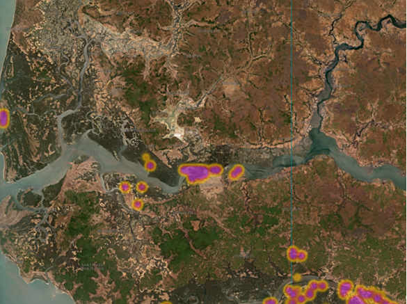
In the heart of Senegal’s Casamance region, a sophisticated early warning system is proving instrumental in the fight to protect vital mangrove ecosystems. The Global Mangrove Watch (GMW) platform, a collaborative initiative utilizing satellite technology, has alerted local conservation teams to critical mangrove degradation in multiple Marine Protected Areas (MPAs). These alerts, often the first indication of a problem, are enabling swift action from organizations like Wetlands International, local authorities, and community stakeholders to identify threats, understand their causes, and implement targeted restoration strategies.

Uncovering Hidden Threats: The Case of Séleki
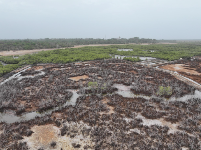
The village of Séleki, nestled within the UKB Marine Protected Area (Ufoyaal Kassa-Bandial), recently became a focal point for conservation efforts following an alert from the Global Mangrove Watch. The platform flagged a concerning loss of approximately two hectares of mangrove cover. Upon receiving this notification, Wetlands International’s local team, comprising Boubacar Sagna and Khadim Diop, joined forces with Capitaine Agustin Sadio, an officer from the Marine Protected Area authority. Their subsequent on-site investigation revealed the source of this silent destruction: man-made dikes.
These dikes, constructed to create ponds for aquaculture, had inadvertently disrupted the natural hydrological balance of the mangrove ecosystem. By blocking the natural ebb and flow of brackish water, the dikes starved the mangroves of the tidal rhythm essential for their survival. Over time, this deprivation led to the gradual wilting and eventual loss of the mangrove stands.

The Indispensable Role of Casamance Mangroves
The mangroves of the Casamance are far more than just coastal vegetation; they are ecological powerhouses that provide indispensable services to both the environment and the local communities. These intricate root systems act as natural barriers, offering crucial protection against the devastating impacts of coastal erosion, flooding, and the accelerating effects of sea-level rise. Beyond their protective functions, mangroves are vibrant nurseries for a rich diversity of marine life. They sustain important fisheries, providing a vital source of protein and income for local populations. Furthermore, they yield valuable products such as oysters and honey, contributing significantly to the livelihoods and food security of the region. The economic value of these ecosystems is substantial, with studies estimating the global economic benefits of mangroves to be in the billions of dollars annually, encompassing coastal protection, fisheries, and tourism.
However, these invaluable ecosystems face a relentless barrage of threats. Anthropogenic pressures, including unsustainable land-use practices and resource extraction, are compounded by the inherent vulnerability of mangroves to natural environmental shifts. The challenge for conservationists lies in the sheer scale of these vast coastal areas. For a limited number of rangers and conservation officers, patrolling and monitoring these extensive MPAs effectively is an almost insurmountable task.
Global Mangrove Watch: A Technological Leap for Conservation
This is precisely where the Global Mangrove Watch platform emerges as a game-changer. By leveraging advanced remote sensing technologies, GMW provides near real-time, high-resolution data on mangrove extent and changes. The platform functions as a sophisticated, space-based surveillance system, offering an unparalleled ability to monitor these critical coastal habitats. For marine protected area managers, conservationists, policymakers, and practitioners, GMW delivers the concrete, evidence-based information needed to respond proactively. This includes identifying illegal logging activities, pinpointing the root causes of local mangrove loss, and meticulously tracking the progress of restoration initiatives.
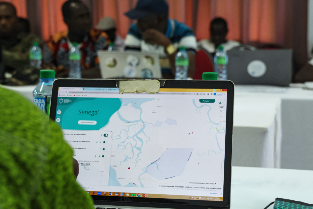
The implementation of GMW’s capabilities in the Casamance has been significantly bolstered by Wetlands International’s "Rooted Resilience" project, generously supported by The Swedish Postcode Lottery Foundation. As part of this initiative, comprehensive training programs have been conducted for a diverse range of stakeholders, including local authorities, community leaders, and students. These training sessions equip participants with the skills to interpret and utilize GMW data effectively. The outcome is a paradigm shift: rangers can now monitor their entire operational areas remotely, allowing them to strategically allocate their limited time and resources towards crucial on-the-ground engagement with communities, fostering collaborative mangrove conservation efforts.
From Aquaculture to Sustainable Livelihoods: The Séleki Transformation
The situation in Séleki serves as a compelling case study for this integrated approach. Following the identification of mangrove loss due to aquaculture dikes, Wetlands International Afrique has initiated a vital dialogue between the Séleki community, the National Aquaculture Agency, and the owner of the dikes. The objective is to collaboratively develop and implement alternative, sustainable livelihood strategies. This process aims to identify and support food security solutions that do not necessitate the disruption of natural tidal flows. The ultimate goal is to facilitate the removal of the dikes, thereby allowing the mangrove ecosystem to recover and regenerate. This approach aligns with the principles of Community-Based Ecological Mangrove Restoration (CBEMR), a methodology that emphasizes working hand-in-hand with local communities to recreate the conditions necessary for natural mangrove regrowth. Alternative livelihood examples include the sustainable harvesting of mangrove honey, as demonstrated in other project sites, which can provide economic benefits without damaging the ecosystem.
Natural Challenges and Human Interventions: Kalone-Bliss Kassa and Niamone-Kalounayes
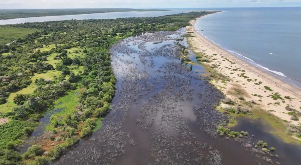
The challenges facing Casamance mangroves are not solely anthropogenic. In the KBK Marine Protected Area (Kalone-Bliss Kassa), GMW detected a different, yet equally significant, instance of mangrove loss. Approximately 16 hectares of mangroves are currently experiencing die-off due to a natural phenomenon: the shifting of a large sand dune. This dune has effectively acted as a natural barrier, impeding the inflow of vital water that sustains the mangrove forest. This particular case underscores the inherent vulnerability of mangroves to the dynamic geological processes of a shifting coastline, even within designated protected areas. This area is recognized as a critical habitat for numerous bird species, including cormorants and egrets, highlighting the ecological significance of preserving these threatened mangroves. An impact study is now underway to assess the potential outcomes of various intervention strategies aimed at mitigating the effects of the shifting dune.
A third alert, issued by GMW in the Niamone-Kalounayes MPA, pointed to clear evidence of mangrove cutting. While the specific reasons for these cuttings remain under investigation, initial assessments suggest potential uses such as fencing for vegetable gardens or harvesting wood for product transformation. The proactive patrolling of the area by MPA authorities, prompted by the GMW alert, is crucial in preventing further degradation and understanding the legality and scale of these activities.
A Future Secured Through Partnership and Technology
The ongoing efforts in Senegal’s Casamance region exemplify a powerful synergy between cutting-edge satellite technology and deeply rooted community engagement, fortified by strong governmental partnerships. This integrated approach is paramount to ensuring the long-term resilience and protection of the Casamance’s vital mangrove ecosystems for generations to come. The journey from a digital alert on a screen to the tangible recovery of a mangrove forest is undeniably a long and complex one. However, in critical locations like Séleki, the initial, vital steps toward ecological healing are already underway, igniting a beacon of hope for the communities whose lives and livelihoods are intrinsically linked to the health and vitality of these extraordinary coastal forests. The success of these interventions will not only safeguard biodiversity but also bolster the climate resilience of coastal communities across the region.
