Cholao, a Lesser Yellowlegs ( Tringa flavipes ), has transcended its avian identity to become a celebrated figure among Audubon’s global social media following. This particular individual’s remarkable migratory journey, initiated in Colombia’s Cauca Valley and culminating in the boreal forests of Canada, has captivated a wide audience due to its meticulous monitoring via a sophisticated GPS tracker. The device meticulously charted its every movement, its monumental crossing of the Gulf of Mexico, its initial landfall in Louisiana, and its subsequent northward trajectory to Saskatchewan, Canada, where it is currently settled for the breeding season.
The profound insights gleaned from Cholao’s odyssey are the culmination of years of dedicated research led by Jorge Velásquez, Audubon’s Science Director for Latin America and the Caribbean. Velásquez, who intimately understands not just Cholao but the collective journeys of 34 other "tringas" – as these shorebirds are affectionately known – has been at the forefront of this groundbreaking tracking initiative. His responses to questions posed by Audubon’s social media community offer a rare and comprehensive glimpse into the extraordinary challenges and patterns that define the epic travels of migratory birds.
The Genesis of a Groundbreaking Tracking Initiative
The endeavor to track the movements of Tringa flavipes commenced in the Cauca Valley, Colombia, in April 2022. The decision to concentrate on the Lesser Yellowlegs was not arbitrary; this species stands out among shorebirds due to its alarming population decline. According to the Partners in Flight database, the Lesser Yellowlegs has experienced an estimated cumulative decline of over 60% in its population since 1970, underscoring an urgent conservation need. Furthermore, this species exhibits a notable association with sugarcane, a predominant agricultural crop in the Cauca Valley, a region where Audubon has intensified its conservation efforts.
Audubon’s work in the Cauca Valley extends beyond mere observation, actively promoting sustainable agricultural practices, particularly the rotation of sugarcane with rice. During the implementation of these initiatives, researchers observed that Lesser Yellowlegs frequently utilized these agricultural landscapes. This discovery ignited a deeper scientific curiosity: were these populations resident throughout the winter, what were their densities, and crucially, what were the origins of these birds? What formidable challenges did they encounter during their arduous journey from their distant nesting grounds to the Cauca Valley? Understanding these dynamics is paramount to developing effective, habitat-specific conservation strategies that span entire migratory flyways.
Evolving Technology: From Motus Networks to Satellite GPS
The methodologies employed for tracking these migratory birds have undergone significant advancements since the project’s inception. Initially, the team relied on Motus stations, a collaborative, international network of automated radio telemetry receiving stations. A critical initial hurdle was the complete absence of Motus infrastructure within the Cauca Valley itself. This meant that the project’s early phases involved not only equipping birds with radio transmitters but also establishing the necessary receiving infrastructure in the region. Velásquez recounts that of the first ten tringas captured and tagged in collaboration with Selva, a prominent Colombian conservation organization, their departure from the country remained unknown due to the lack of local Motus coverage at that time.
Motus technology, while instrumental and the recipient of substantial investment in time and resources for tracking tringas, possesses a significant limitation: its functionality is contingent upon network coverage. While coverage is robust across much of the United States, certain nations in northern South America, including Colombia, and parts of Central America, it becomes notably sparse once birds venture across the Canadian border, particularly in the continent’s central regions. This geographical constraint posed a considerable challenge, creating extensive "blind spots" in the migratory data.
Bridging the Gaps in Migration Data
The limitations of Motus meant that for years, the fate of many of the approximately 30 tagged birds became a mystery once they progressed beyond North Dakota. To overcome this critical data gap, the research team began incorporating satellite transmitters into their tracking arsenal last year. These advanced devices offer a significantly improved understanding of local movements and provide continuous data, regardless of proximity to a ground-based receiving station. The hope now is that Cholao and its counterparts, equipped with this cutting-edge technology, will finally reveal the precise locations of their nesting grounds, a piece of the migratory puzzle that has long remained elusive. This technological leap represents a crucial step in understanding the full life cycle of these declining shorebirds.
Unraveling Migratory Pathways: Cholao’s Blueprint and Beyond
The question of whether these birds adhere to consistent migration routes year after year, both northward and in their return to the Cauca Valley, is central to understanding their ecology. Velásquez affirms that discernible patterns do emerge from the data collected from the thirty tringas equipped with radio transmitters and the five now carrying satellite devices. During the spring migration, typically in April and May, birds appear to be engaged in a rapid, purposeful sprint towards their nesting territories in the boreal regions of North America. Their chosen path largely follows the Midcontinent Flyway, a highly efficient, almost linear corridor traversing the central states of the United States. However, once they cross the northern U.S. border, the exact continuation of their journey becomes less clear, with possibilities including further straight-line travel or diversions towards Alaska, another known nesting area for the species.
The Enigmatic Variability of Fall Migration
In stark contrast to the relatively straightforward spring migration, the fall migration exhibits considerably more variability. Some individuals continue to utilize the central states, making strategic stopovers likely for foraging and energy replenishment. Others embark on intriguing detours: some tringas have been recorded entering the U.S. through Minnesota and North Dakota, while others veer eastward, traveling as far as New York before descending along the Atlantic Coast. A third group traverses the central U.S., ending up in states like Kentucky, Tennessee, and South Carolina, before departing via Florida. Yet others simply retrace the spring migration route. This pronounced variability in fall migration underscores the complex decision-making processes birds undertake, possibly influenced by weather conditions, food availability, or individual experience.
The question of whether birds travel in family groups during these migrations remains largely unanswered by current research, though Velásquez expresses a personal interest in this aspect. What is unequivocally known, however, is the intense physiological preparation preceding these massive migratory leaps. Both before and after significant legs of their journey, birds engage in periods of frantic feeding, known as hyperphagia, to accumulate vital fat reserves. Cholao’s GPS data strikingly illustrated this: an uninterrupted, two-and-a-half-day flight from Cali, Colombia, to the Louisiana coast. Upon arrival, Cholao spent approximately a week in one location, undoubtedly recovering, foraging, and rebuilding energy reserves. Subsequently, it continued its journey to Iowa, likely drawn to a large swamp offering abundant food, before finally making its way to Saskatchewan, Canada.
The Physiological Demands of Epic Journeys
Migration is one of the most energetically demanding feats in the natural world. Cholao’s followers frequently inquire about how Lesser Yellowlegs sustain themselves during such arduous travel. While not an expert in migration ecology, Velásquez explains the general principle: weeks prior to commencing migration, most migratory birds enter a phase of intense feeding to maximize their fat reserves. These lipid stores serve as the primary fuel source for their journey. While some species, such as raptors, can make opportunistic stops to hunt along their route, many passerines and shorebirds, particularly those crossing vast oceans, are entirely dependent on these accumulated energy reserves. Upon making a "stopover" – a crucial resting and refueling point – they replenish their reserves before undertaking the final push to their breeding grounds. This strategic use of stopovers is critical for survival.
Speed and Endurance: The Mechanics of Avian Flight
Another compelling query from Cholao’s admirers concerns the flight speed of Lesser Yellowlegs. Based on the recorded data, particularly during their oceanic crossings, and factoring in variables such as wind direction and weather conditions, these birds average speeds of approximately 25 to 30 miles per hour (roughly 40 to 48 kilometers per hour). This sustained speed over thousands of miles highlights the incredible endurance and aerodynamic efficiency of these relatively small birds.
Climate Change: A Growing Shadow on Migratory Patterns
The potential influence of climate change on migratory timing and routes is a significant concern for conservationists. One observed phenomenon is the occurrence of "false springs." Warmer temperatures in March or April can prematurely signal the arrival of spring, prompting many birds to initiate their breeding cycles or other seasonal activities. However, if these warm spells are followed by a sudden frost, birds can suffer severe consequences, including the loss of nests and the immense energy invested in breeding. This phenological mismatch – when the timing of biological events no longer aligns with environmental cues – is a direct consequence of climate change and poses a serious threat to migratory bird populations by disrupting their finely tuned life cycles. The changing climate could also alter resource availability along traditional migration routes, forcing birds to adapt or face increased mortality.
Translating Data into Conservation Action
The comprehensive data collected through these tracking efforts holds immense practical value, directly informing conservation strategies and decision-making processes. This information is crucial for defining and designating protected areas, crafting targeted conservation campaigns, and building a robust repository of knowledge for future scientific study.
For the Motus network, identifying migratory bird stopover sites – often metaphorically referred to as "restaurants" and "hotels" – is a primary objective. When data from dozens or even hundreds of tagged individuals is aggregated, distinct patterns emerge, highlighting critical areas of heavy usage along specific migration routes. This allows conservation organizations like Audubon to pinpoint threats to these vital locations and implement focused actions to mitigate them, such as habitat restoration, pollution control, or advocating for land protection.
Equally impactful is the granular detail provided by GPS tracking on a more local scale. This data can precisely identify which specific lands, rivers, or even agricultural crops tringas utilize within the Cauca Valley and how they allocate their time there. The sheer volume and specificity of this incoming information are, as Velásquez describes, "overwhelming, impressive!" This allows for highly localized, effective conservation interventions.
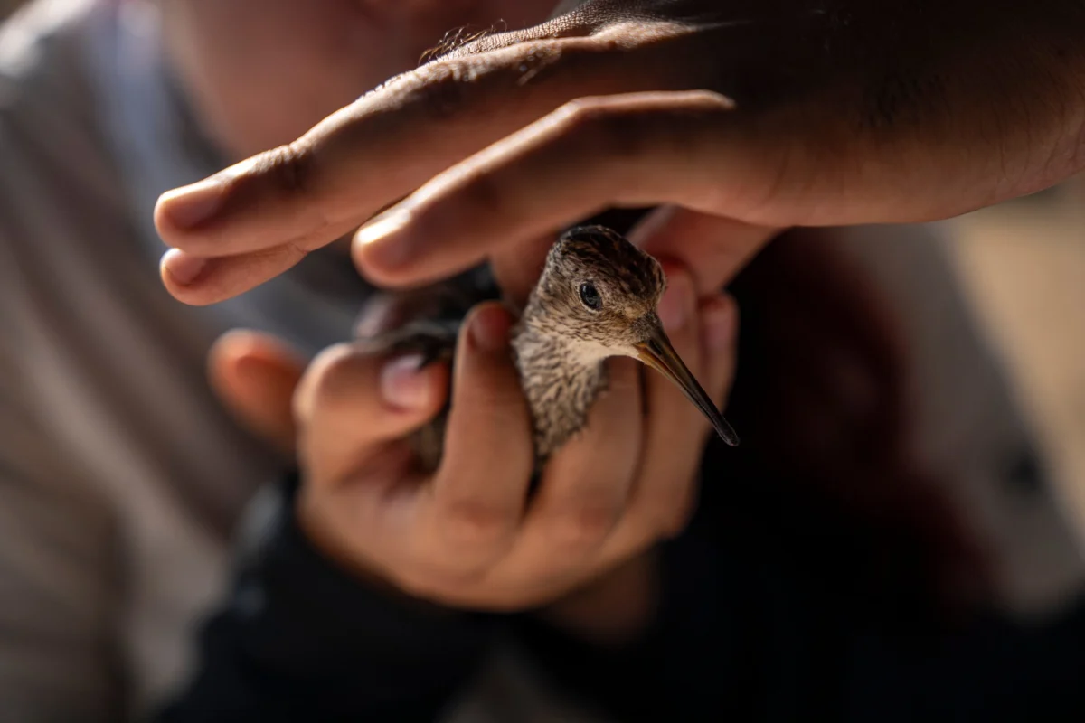
The Science Behind the Backpack: Minimizing Impact, Maximizing Insight
The equipment carried by these birds, whether Motus transmitters or satellite GPS devices, is ingeniously designed for minimal impact. Both types of transmitters are tiny, lightweight "backpacks" worn on the bird’s back. While the shape and weight vary slightly – Motus transmitters are flatter and weigh less than two grams, satellite ones weigh precisely two grams – the fundamental design prioritizes the bird’s well-being.
A paramount concern is the potential for these devices to affect bird mortality, not necessarily by making them more vulnerable to predation, but by potentially limiting mobility if the harness is improperly fitted. To address this, only highly trained personnel are authorized to install the transmitters. Another critical factor is the energetic cost of migration; even two grams can make a significant difference. Consequently, a strict guideline in migration studies is to keep transmitter weight under 3% of the individual’s body weight. This threshold ensures that the added burden does not unduly compromise the bird’s ability to complete its arduous journey. Until recently, attaching satellite transmitters to a bird as small as a tringa was deemed impossible due to the size and weight of available technology, but miniaturization has opened new frontiers in avian research.
The Lifespan and Innovation of Tracking Devices
Both GPS and Motus transmitters are designed for longevity, harnessing sunlight to generate power. Motus devices are equipped with a battery that recharges via solar energy, rendering them virtually "eternal," much like satellite transmitters. However, the longest recorded tracking period for a single individual in this project has been two years. It is believed that beyond this timeframe, the nylon harness, subject to environmental wear and tear, eventually degrades and falls off, naturally shedding the device. This self-releasing mechanism is an important ethical consideration, preventing long-term encumbrance.
Surprising Discoveries and Future Directions
Among the myriad data points collected, one particular finding has profoundly surprised Velásquez: the unexpectedly strong association between tringas and human-modified agricultural habitats. Initially, there was an expectation that these shorebirds would primarily seek natural wetlands, such as the Sonso lagoon or the Cauca River, within the valley. However, the data revealed an "incredible" and pervasive connection between Lesser Yellowlegs and rice crops. They are practically ubiquitous wherever rice is cultivated.
This revelation carries significant implications for conservation strategy. It unequivocally indicates that the project is on the right track, validating the focus on implementing bird-friendly practices within the Cauca Valley’s agricultural landscapes. These rice crops, far from being mere human constructs, emerge as a "key piece of the migratory puzzle," providing crucial foraging and resting habitat for these long-distance travelers. This discovery underscores the potential for integrating biodiversity conservation with sustainable agriculture, transforming working landscapes into vital components of a healthy migratory flyway. The ongoing monitoring of Cholao and its kin continues to illuminate the intricate lives of these remarkable birds, providing indispensable knowledge for their enduring protection.
