
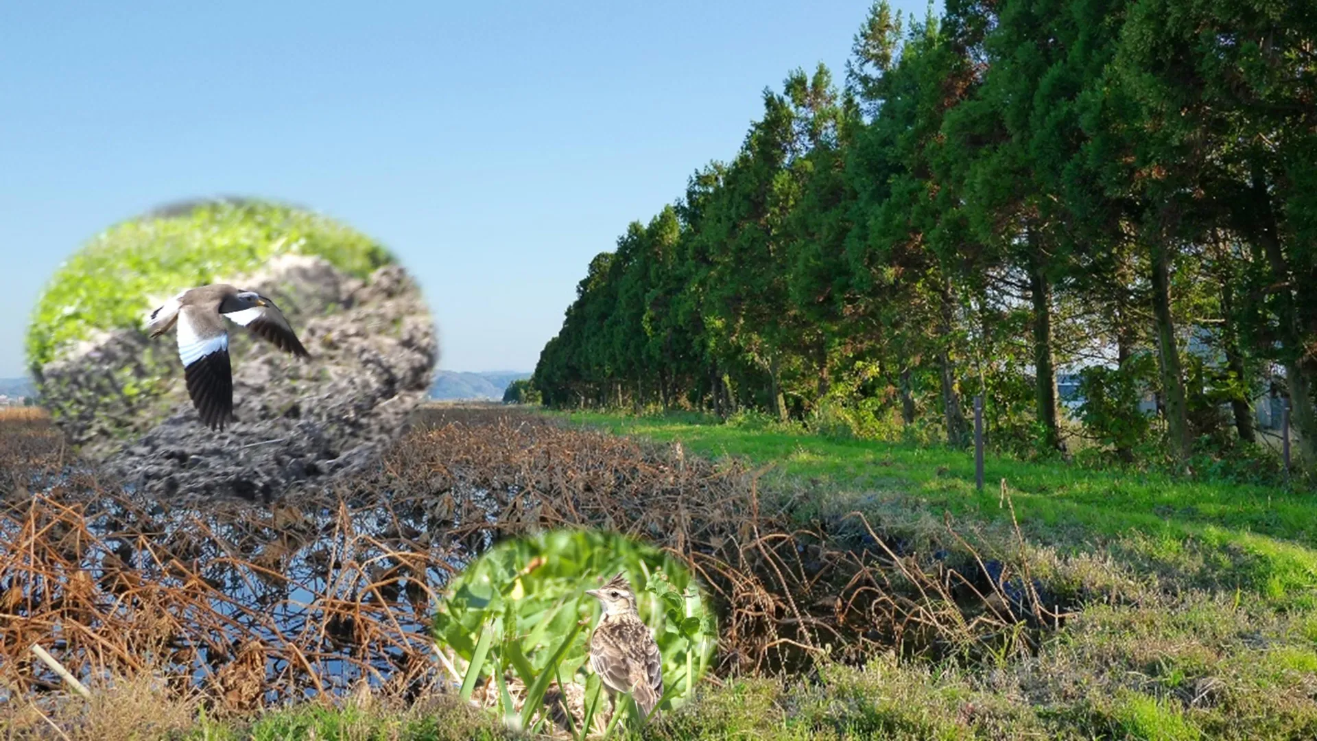
The global push to enhance agricultural biodiversity through large-scale tree planting initiatives has long been considered an unalloyed environmental victory. From the European countryside to the Great Plains of North America, conservation programs routinely incentivize farmers to plant shelterbelts—linear rows of trees and hedgerows designed to mitigate wind erosion, protect sensitive crops, and provide microhabitats for local wildlife. However, a groundbreaking study published in the Journal of Environmental Management suggests that this one-size-fits-all approach to conservation overlooks a complex ecological trade-off, particularly within agricultural wetland ecosystems.
Conducted by an interdisciplinary team of researchers from institutions including Hiroshima University, The University of Tokyo, and Kyoto University, the study reveals that while shelterbelts successfully bolster populations of shrub-dwelling and edge-adapted species, they simultaneously degrade the habitat quality for numerous birds that depend on open landscapes. In wetland farming systems—such as the intensively managed rice paddies that dominate much of Asia—these linear forestry features can inadvertently precipitate steep declines in the abundance and diversity of native and migratory open-habitat avian species. As governments and environmental agencies worldwide grapple with escalating biodiversity loss, these findings underscore the urgent need for nuanced, context-specific land-use planning that accounts for the distinct ecological requirements of both wooded and open-air species.
Unpacking the Ecological Complexities of Agricultural Wetlands
Agricultural wetlands occupy a unique and paradoxical position in modern environmental management. On one hand, they are heavily modified anthropogenic landscapes engineered primarily for high-yield food production. On the other hand, because centuries of industrial development and urban expansion have eradicated the vast majority of natural wetlands globally, these engineered aquatic ecosystems now function as critical surrogate habitats. This is particularly true for migratory birds navigating major international flyways, such as the East Asian-Australasian Flyway, which spans from the Russian Far East and Alaska down to Australia and New Zealand.
In these wet-farmed regions, rice paddies, lotus fields, and shallow irrigation basins serve as vital feeding, resting, and wintering grounds for hundreds of bird species. Conservation biologists have increasingly recognized that the survival of these migratory populations hinges on the ecological integrity of agricultural landscapes. Consequently, local and national governments have introduced sweeping agri-environmental schemes encouraging the integration of woody elements to foster biodiversity.
Yet, the empirical data supporting the efficacy of shelterbelts has historically been derived from terrestrial cropping systems and dry grasslands in Western nations. Until recently, very little was known about how the introduction of vertical, woody structures alters the delicate dynamics of wetland-dominated farming regions across Asia. This knowledge gap prompted lead author Masumi Hisano and her colleagues to investigate whether linear tree plantings uniformly benefit all farmland birds, or if they disproportionately disadvantage species adapted to expansive, unobstructed vistas.
Chronology and Methodology of the Lake Kahokugata Study
To test these hypotheses, the research team focused their empirical investigation on the agricultural landscape surrounding Lake Kahokugata in central Japan. This specific region serves as an ideal living laboratory for studying the interactions between intense agriculture, climatic pressures, and avian ecology. Situated near the coast, the Kahokugata basin experiences severe, biting winter winds and coastal storms originating from the Sea of Japan. To protect fragile crops and prevent topsoil erosion, local farmers have historically integrated dense networks of windbreaks and shelterbelts throughout the flat terrain.
Furthermore, Lake Kahokugata is a globally recognized ecological node along the East Asian-Australasian Flyway. The region hosts a bifurcated avian community: wintering species that travel south to escape sub-zero conditions in the north, and summer breeding species that utilize the rich aquatic resources of the flooded paddies during warmer months. Historical records indicate that nearly 300 distinct bird species utilize the Kahokugata basin throughout the annual cycle.
To capture these seasonal fluctuations and measure the precise structural impact of shelterbelts, the research team deployed a rigorous point-count survey methodology across two distinct temporal windows:
- Late Winter Baseline (February and March 2021): Focused on capturing the distribution, abundance, and diversity of wintering migratory waterbirds and resident open-field species during peak windbreak utility.
- Summer Breeding Season (June 2023): Designed to evaluate how breeding resident birds utilize the landscape during active agricultural production periods when crops are actively growing.
During these surveys, observers recorded bird species, population counts, and environmental variables across numerous sites, comparing areas immediately adjacent to shelterbelts with open control sites located approximately one kilometer away from any major woody linear features.
Empirical Findings: Winners, Losers, and Ecological Walls
The analytical results of the surveys exposed a stark, quantitative ecological dichotomy. Shelterbelts undeniably fulfilled their secondary conservation function by providing localized refuges for species adapted to shrublands, woodlands, and habitat edges. Birds that rely on woody perches, dense foliage for nesting, and intermediate cover found these linear tree rows highly advantageous.
However, for species intrinsically tied to open grasslands and wetlands, the presence of shelterbelts proved profoundly detrimental. The data demonstrated a dramatic compression of both population density and species richness among open-habitat birds residing near windbreaks.
According to Dr. Hisano, the quantitative drop in population was statistically overwhelming. The abundance of grassland birds was recorded at more than 70 percent lower in agricultural fields immediately adjacent to shelterbelts compared to the open control sites situated a kilometer away. This localized depression in numbers suggests that even relatively narrow, strip-like rows of trees exert a disproportionate influence over the spatial utilization of the landscape by wildlife.
The researchers conceptualize these phenomena through a vivid metaphor. Rather than acting as benign landscape enhancements, shelterbelts function essentially as "ecological walls." By vertically fragmenting the landscape, they physically and behaviorally restrict the territory of birds that rely on uninterrupted lines of sight for predator detection and foraging. Furthermore, the introduction of trees creates ideal corridors and perches for avian and terrestrial predators—such as corvids and small mammals—thereby increasing predation pressure and nest failure rates for ground-nesting species that inhabit the open paddies.
Implications for Global Agri-Environmental Policy
The publication of these findings in the Journal of Environmental Management arrives at a critical juncture for global environmental policy. As nations race to meet international biodiversity targets, agricultural subsidies and incentive programs are increasingly tied to environmental stewardship metrics, prominently including tree-planting mandates.
The Hiroshima University study does not argue that tree planting is inherently harmful; rather, it challenges the pervasive assumption that ecological interventions are universally positive regardless of context. By demonstrating that small-scale landscape configurations can trigger cascading, large-scale ecological consequences, the research highlights the necessity of localized ecological intelligence in land-use planning.
In heavily modified agricultural wetlands, maximizing biodiversity cannot be achieved by simply blanketing the countryside in trees. Instead, policy planners must adopt a holistic, landscape-level perspective that weighs structural complexity against the distinct habitat requirements of open-space specialists. For regions where natural wetlands have been systematically replaced by rice cultivation, protecting the remaining open character of the landscape is just as vital as preserving forest patches.
Future Directions and the Path to Evidence-Based Conservation
Recognizing the complexity of these interactions, the research team emphasizes that further scientific inquiry is necessary to refine agricultural management strategies. Future research phases will aim to dissect how specific structural variables—such as the width, height, canopy density, species composition, and spatial configuration of shelterbelts—interact with avian communities across different geographic regions and microclimates.
Additionally, scientists hope to model the indirect physiological and behavioral impacts of linear plantings, including how windbreaks influence micro-predator dynamics, insect vector distribution, and interspecific competition among foraging birds.
Ultimately, the overarching objective of this ongoing research is to equip policymakers, conservationists, and agricultural extension officers with the empirical tools required to design truly balanced agri-environmental policies. By moving away from dogmatic, one-size-fits-all prescriptions like universal afforestation, land managers can craft mosaic landscapes that thoughtfully integrate both open vistas and strategic woody features. This sophisticated approach ensures that agricultural wetlands can continue to fulfill their primary economic mandate of feeding human populations while simultaneously maintaining resilient, biodiverse ecosystems capable of sustaining migratory wildlife in an era of rapid environmental transformation.
The research team behind this study comprised Masumi Hisano (Hiroshima University, The University of Tokyo, and Kyoto University); Shota Deguchi (Fukui City Museum of Natural History); Wenhuan Xu (University of British Columbia and Simon Fraser University); Xike Xiao (Hiroshima University); Keinosuke Sannoh (Nihonkai Eco Engineering Technologies); Xinli Chen (Zhenjiang A&F University); and Ken Motomura (Nakano City Hall). Financial and logistical support for the project was provided by the Kahokugata Lake Institute and the Japan Society for the Promotion of Science KAKENHI.
