A delicate yet critical balance defines the global pursuit of a sustainable future: the urgent need to deploy renewable energy sources rapidly to avert ecological collapse must be meticulously weighed against the imperative to protect vulnerable wildlife and their habitats. The most effective and economically sound strategy to ensure that wind turbines and solar arrays do not inadvertently harm avian populations lies in their strategic placement – away from sensitive species, vital breeding grounds, and major migratory corridors, where potential impacts can be minimized or more easily mitigated.
This strategic approach is increasingly being facilitated by the widespread adoption of sensitivity maps, powerful spatial tools designed to identify areas that must be avoided during renewable energy development. These maps are gaining significant traction across both industry and governmental sectors, with BirdLife International and its network of partners at the forefront of their development and implementation. The pioneering AVISTEP (Avian Sensitivity Tool for Energy Planning) was the first of its kind, initially focusing its efforts on Africa and Asia. Over time, BirdLife’s European partners have adapted and refined the AVISTEP methodology, leveraging local data to create bespoke national sensitivity maps, marking a significant leap forward in integrated environmental planning.
The Urgent Imperative for Renewables and the Underlying Biodiversity Challenge
The European Union, driven by ambitious climate targets and initiatives like REPowerEU, is currently engaged in a high-stakes race to designate dedicated Renewable Acceleration Areas (RAAs) across both terrestrial and marine environments. These RAAs are intended to fast-track renewable energy projects, yet the initial criteria for their identification often prioritize factors such as high wind or solar potential and existing infrastructure, sometimes without fully integrating comprehensive biodiversity parameters. This oversight carries inherent ecological risks, potentially placing vital ecosystems and species in jeopardy if not carefully managed. Sensitivity maps, therefore, emerge as a key science-based instrument, offering Member States a robust framework to achieve strategic spatial planning that minimizes adverse impacts on biodiversity from the outset. They serve as a crucial pre-planning filter, ensuring that the foundational principle of the mitigation hierarchy—avoidance—is upheld before any ground is broken or turbines are erected.
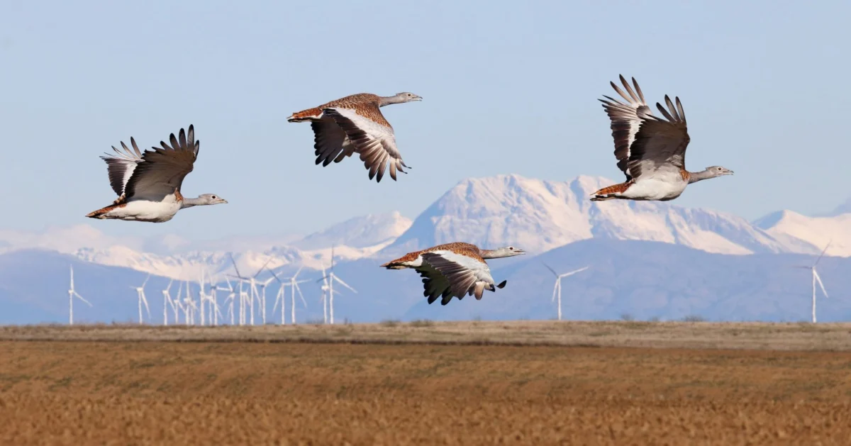
The concept of balancing energy needs with ecological preservation is not new, but the scale and urgency of the current energy transition amplify its importance. Europe is home to an incredible diversity of bird species, many of which are migratory, traversing vast distances between breeding and wintering grounds. Major migration routes, such as the Strait of Gibraltar, are critical bottlenecks where large numbers of birds concentrate, making them particularly vulnerable to infrastructure development. Wind farms, in particular, pose risks of collision and habitat displacement, while large-scale solar installations can fragment landscapes and alter local ecosystems. The strategic application of sensitivity mapping ensures that these environmental considerations are embedded at the earliest stages of planning, rather than being addressed as an afterthought, thereby fostering a truly sustainable energy transition.
The Genesis and Evolution of Avian Sensitivity Mapping: From AVISTEP to National Solutions

The journey of avian sensitivity mapping began with AVISTEP, a groundbreaking initiative that provided a systematic methodology for assessing bird vulnerability to energy infrastructure. This tool, initially deployed in regions like Africa and Asia where energy development was rapidly accelerating, established the foundational principles for identifying critical bird areas, migration pathways, and species-specific sensitivities. It combined extensive ornithological data, including species distribution, population sizes, breeding sites, and migration patterns, with geographical information system (GIS) technology to generate comprehensive risk assessments.
As the focus shifted to Europe, the challenge lay in adapting this global methodology to the continent’s diverse landscapes, unique avian fauna, and varying regulatory frameworks. BirdLife’s national partners, with their deep understanding of local ecology and policy, took on this task. They meticulously gathered and integrated national-level data, including detailed bird atlases, GPS tracking data of individual birds, and local environmental regulations, to create highly granular and accurate sensitivity maps. This localized approach ensures that the maps are not only scientifically robust but also politically relevant and actionable for national and regional planning authorities. The collaborative effort across global and regional teams exemplifies a commitment to both scientific rigor and practical application, ensuring that these tools are not just academic exercises but vital instruments for conservation.
Real-World Impact: Pioneering Success in Spain and Portugal
The practical efficacy of avian sensitivity maps is perhaps best illustrated by their tangible impact in countries like Spain and Portugal, where the intersection of high renewable energy potential and rich biodiversity creates both opportunities and challenges.
Spain: A Legacy of Proactive Conservation
In Spain, BirdLife’s partner, SEO/BirdLife, has been at the vanguard of this movement since the nascent stages of wind energy development. Their journey began in the 1990s, when the first wind farms emerged in Tarifa, a region strategically located within the Strait of Gibraltar – one of the world’s most critical bottlenecks for migratory birds. Recognizing the immense ecological value of such areas, SEO/BirdLife adopted a proactive, and at times, litigious stance. They did not shy away from legal action against projects that were proposed or constructed in areas of high ecological value, particularly those threatening sensitive species. This early activism laid the groundwork for a more sophisticated, preventative approach.
Today, SEO/BirdLife is a leader in developing comprehensive bird sensitivity maps for onshore wind, offshore wind, and solar photovoltaic installations across Spain. These maps represent a paradigm shift, embodying the first and most crucial step of the mitigation hierarchy: avoiding damage before it occurs. By clearly delineating "no-go" zones and areas of varying sensitivity, these tools prevent harmful developments from ever being initiated in biodiversity hotspots. A spokesperson for SEO/BirdLife, reflecting on their decades of experience, might emphasize, "Our maps are not just about identifying risks; they are about guiding sustainable development. We learned early on that prevention is far more effective than trying to mitigate damage after it has occurred. These maps are a game-changer, embedding conservation into the very DNA of energy planning." This proactive strategy ensures that Spain’s ambitious renewable energy targets can be met without compromising its extraordinary natural heritage.
Portugal: Data-Driven Policy Revisions
Just across the border, in Portugal, BirdLife partner SPEA has demonstrated the transformative power of robust scientific data in influencing government policy. SPEA’s groundbreaking offshore sensitivity maps focused on 34 specific seabird species known to be vulnerable to collision with turbines or displacement from critical feeding and breeding areas. These maps were developed with meticulous attention to detail, integrating data on foraging ranges, migration routes, and population dynamics of species such as shearwaters, petrels, and gannets.

The impact of SPEA’s work was profound. Their data had a significant influence on an already finalized national deployment plan for offshore wind energy. Specifically, the maps revealed high avian sensitivity in several areas that had been pre-identified by the government through its Marine Rapid Readiness Assessment. As a direct result of SPEA’s scientific input, one originally proposed RAA, Ericeira, was entirely removed from the plan, and another, Viana do Castelo, saw its designated area significantly downsized. This case vividly illustrates that while sensitivity maps are ideally used to guide the initial declaration of RAAs, they can also serve as powerful tools for course correction, driving essential changes and preventing negative ecological impacts even when plans are already advanced. A senior researcher at SPEA could note, "Our objective was to provide undeniable scientific evidence. The fact that our maps led to tangible changes in a government-approved plan underscores the critical importance of integrating biodiversity data early and effectively. It proves that evidence-based conservation can directly shape national policy."
Expanding Influence: Shaping Government Decisions in Italy and Poland
The success stories in the Iberian Peninsula are not isolated incidents. With crucial funding from the European Climate Foundation (ECF), BirdLife partners in Italy (LIPU) and Poland (OTOP) have also produced sophisticated avian sensitivity maps for both onshore and offshore wind development, further cementing their role as indispensable planning tools.
Italy: A Clear Visual Standard
In Italy, LIPU’s maps have adopted a clear and intuitive traffic light colour system. The most sensitive areas, representing significant risks to avian populations, are vividly indicated in red, while areas with minimal sensitivity are coloured green. This visual simplicity enhances accessibility and usability for planners, developers, and policymakers alike. Furthermore, protected areas – such as Natura 2000 sites, Important Bird and Biodiversity Areas (IBAs), and national parks – are prominently marked in grey across the maps. These grey zones are strictly off-limits for construction, unequivocally signalling their high ecological value and legal protection.
LIPU’s maps have already achieved considerable success at the local and regional levels. In some of Italy’s windiest regions, such as Sardinia, the grey layer denoting protected areas is increasingly recognized and respected by administrative bodies, becoming a de facto standard in project assessment. This growing acceptance highlights the potential for these maps to streamline approval processes by directing development away from conflict zones from the outset. A representative from LIPU might comment, "The intuitive design of our maps, especially the traffic light system and the clear demarcation of protected areas, has fostered rapid understanding and acceptance among local municipalities. It’s simplifying complex ecological data into actionable planning guidance."
Poland: Collaborative Design for Maximum Impact
In Poland, OTOP’s maps employ a system of different tones and gradations of a single colour. This design choice was a direct outcome of extensive consultations with key decision-makers, including government authorities and representatives from the business sector. This collaborative approach ensured that the maps were not only scientifically robust but also maximally effective and usable within the Polish planning context. The integration of protected areas as grey zones, similar to the Italian model, reinforces their inviolable status.
The Polish sensitivity maps have achieved a significant milestone: they have been recommended as a mandatory requirement in government guidelines for the technical specification of renewable energy mapping potential. This official endorsement is a testament to the rigorous methodology and the extensive, inclusive consultations undertaken by OTOP, which notably involved the Polish Wind Energy Association. Such collaboration between conservationists, government, and industry is crucial for integrating biodiversity concerns seamlessly into national energy strategies. A spokesperson for OTOP could remark, "Engaging with decision-makers and the industry from the very beginning was paramount. Their input helped us tailor the maps to be truly practical and impactful, leading to their formal recommendation in government guidelines – a huge step towards embedding biodiversity protection into national energy planning."

Broader Adoption and Standardization Across Europe
The successes in Southern and Central Europe are part of a wider trend across the continent. BirdLife International and its partners are increasingly recognized as authoritative sources for avian sensitivity mapping. While other organizations are also developing similar tools, the BirdLife Partnership was among the first to systematically advance this approach in numerous countries. Partners in Bulgaria, the United Kingdom, Czechia, Hungary, Ireland, Romania, Slovenia, Croatia, Finland, and Malta have all produced and continue to refine onshore and offshore wind maps.
As European nations intensify their efforts to accelerate renewable energy deployment, there is a burgeoning demand to expand the reach of these sensitivity maps to additional countries, including Greece, Iceland, and Georgia. This widespread adoption underscores the growing recognition that integrating biodiversity data into spatial planning is not merely an environmental nicety but an essential component of responsible and sustainable development. BirdLife’s leadership in this domain positions them as a key player in shaping the future of Europe’s energy landscape. The collective expertise and consistent methodology across the partnership ensure a high standard of data quality and interpretation, moving towards a potential new European standard for responsible renewable energy siting.
Navigating Challenges and Embracing Best Practices
Despite their intuitive design and scientific rigor, sensitivity maps are sophisticated tools that require careful interpretation. Misunderstandings can occur, potentially leading to incorrect planning decisions. To mitigate this, BirdLife’s partners have developed comprehensive recommendations and indicators for governments and industry stakeholders on how to best read and utilize these maps. These guidelines clarify methodologies, explain data layers, and provide context for sensitivity classifications.
Crucially, these recommendations also emphasize a vital caveat: sensitivity maps are intended as a pre-planning and strategic spatial planning tool, and they do not replace more detailed, site-specific environmental assessments. Environmental Impact Assessments (EIA), Strategic Environmental Assessments (SEA), and Appropriate Assessments (AA) remain indispensable components of the project approval process. The maps serve as an initial filter, guiding developers towards less sensitive areas, thereby making subsequent, more detailed assessments more efficient and effective. Continuous dialogue and training with authorities and the business sector are therefore vital to ensure these powerful tools are used to their maximum potential.
The Mitigation Hierarchy: A Holistic Framework for Sustainable Development

It is imperative to understand that sensitivity maps, while foundational, represent only one piece of a larger, integrated puzzle. They embody the first step of the mitigation hierarchy: avoidance. For truly sustainable renewable energy development, the entire hierarchy must be rigorously respected: avoidance, followed by mitigation (reducing unavoidable impacts), restoration (rehabilitating damaged areas), and finally, offsetting (compensating for residual impacts that cannot be restored).
Achieving harmony between nature conservation and the rapid deployment of renewables necessitates that science-based solutions consistently lead the way, minimizing impacts on biodiversity at every stage. This also calls for parallel innovations in energy saving and efficiency technologies, reducing the overall demand for new infrastructure. Governments have a critical role to play in strengthening strategic investments in nature restoration, fostering the political will to enforce sound spatial planning, and ensuring effective management of protected areas. They must create an enabling environment for developers to undertake "good" projects – those that deliver clean energy while upholding ecological integrity.
Ultimately, protecting nature is not a barrier to progress; it is a win-win scenario for wildlife, for society, and for the long-term viability of the renewable energy industry itself. By integrating biodiversity concerns through robust tools like sensitivity maps and adhering to the full mitigation hierarchy, we can navigate the challenging yet crucial decades ahead, securing both a stable climate and a thriving natural world. Sensitivity maps are a vital part of this journey, ensuring that the clean energy revolution also protects the birds we cherish.
